30/04/2018

EA8/GC-006 (Tamadaba)


I followed the same track as OE5EEP, so I didn't record one. His track is here :
https://www.sotamaps.org/tracks/summit/EA8/GC-006

It took me more than 2 hours to drive from Gàldar to the parking spot at Casa Forestal.
There were preparations for a rally the next weekend, and many roads were blocked, and deviations not always indicated very clearly ... so with a lot of delay I could start the ascent to Tamadaba.
Heinz OE5EEP describes it as a "family friendly tour" ...
Maybe all the delay had put me in a bad mood, or was it the rather chilly 7°C, but I don't agree with Heinz, I found it quite a long and tiresome walk ...
Of course, the nice views compensate for the effort one has to make !


Anyway, about one hour later I could find a spot to setup , on a pile of rocks that looked like the highest point. In 90 minutes, I made 24 QSO's, including 5 S2S, so not a bad result at all.
My mood was already better as you can see, hi.


Descending from Tamadaba, my mood suddenly cleared up even more, by this wonderful view : the peak of El Teide on Tenerife, with some snow patches clearly visible. One day I should go there to activate ...


After this summit, I took a couple of days rest without SOTA.
I did some real "tourist" stuff, like visiting the museum of "Cueva Pintada" in Gáldar, the lighthouse "Faro de Punta Sardina, and of course I had to go to beach too ... I enjoyed the nice beach at Sardina del Norte, which has free parking (not the case in many other places).

After that, I had to drive all around the island, to my final AirBnb stop in Los Caideros near Arguineguín, on the South coast of Gran Canaria. There I took some more "vacation" , but still had two more summits on my list ...

Next summit

or

Back to overview

29/04/2018

EA8/GC-025 (Pico de Gáldar)


Pico de Gáldar is an extinct volcano near the city of Gáldar. To the summit, it's an easy 25 minutes walk along gravel road, from the parking spot at the end of Calle Méjico at 28.153490, -15.636915. 
I have seen a car drive up to the summit too, it is not forbidden, but I didn't want to wreck my little rental car ... the road is full of potholes.
The track is on the SMP, but you don't really need it.
https://www.sotamaps.org/tracks/summit/EA8/GC-025


Near the parking spot is a small monument, and from there you have a nice view over the ocean, and the many banana plantations. 
Along the track you will also see a nice cave (indicated on the map above).


This summit could as well be called the "Pico de las Torres", because it is full of radio towers ... see for yourself :


The main tower probably couldn't take any more antennas, so they decided to put some more , smaller towers beside it ... hi.


On the eastern slope of the summit are a number of crucifixes, forming a calvary, and possibly along another track to the summit. But just like Heinz, OE5EEP, I didn't investigate any further.


I did setup my station just below the crosses at the main tower, and had no interference.
18 QSO's in the log, alas no DX, but a nice S2S with friend Michael DB7MM/P !


As a funny note : from my operating position I could see the roof terrace of the apartment where I stayed. I took a picture with the 30x zoom lens in my pocket camera.
In the morning , the friendly lady had helped me doing some laundry (I was halfway my trip and only brought enough clothes for 10 days ..).
I could easily check that my laundry was still hanging on the line ...  hi (click the picture to enlarge).


Next summit

or

Back to overview

28/04/2018

EA8/GC-024 (Amagro)


After staying with the friendly Zumba teacher in Santa Brígida for one week, it was time to move on to my next stop in Gáldar, where I stayed 5 nights, with another friendly lady and her friend.

The road brings you all along the north coast of Gran Canaria, and I stopped at a few places to enjoy the view over the (rough) seas ... but then it was time to focus again : SOTA time !


Amagro is a fairly easy one pointer.
The easiest way is to park here 28.120167, -15.680154 , just 100m further to the right from the gate of the "Sociedad de Cazadores" (see picture above).

At the ruins, the track is indicated with white arrows, and goes steadily up in easterly direction.
At some point the track descends for a while, then goes up again.
NOTE : this track is not on OSM or OT.


The last and steepest part takes you North to the ridge between the two high points on the summit, the one you need is taking a right turn, this is Amagro (500m, 496m on OSM), the other point is called Alto de los Mojones (502m on OSM), it is a bit confusing, but doesn't matter much, both peaks are in the AZ anyway.
My track on SMP is not complete, but the last part is easily followed on OSM or OT.

I reached the summit in 45 minutes, descent was only 30 minutes.


Y


In the distance is Pico de Gáldar, my next summit !


You'll know you're right if you reach the crosses, which were once fully covered with mirriors.
A lot of the pieces of mirror have now fallen off.
Nearby is a nice  pile of rock to use as a "shack" !  


I had a good run of 28 QSO's, including 6 S2S, and one DX with KA1R, all on 20m SSB and CW.

Next summit

or

Back to overview


26/04/2018

EA8/GC-002 (Roque Nublo)


During my activation of Morro de la Hierba Huerto (see report here), I had a nice view of the "impossible" summit, Roque Nublo .. or freely translated  "Rock in the Clouds".
To have a valid activation, one would have to climb the 67m high volcanic rock. So it is not really impossible, but I'll leave this summit to others ...

On the return from my activation, I had to pass the parking lot for Roque Nublo , so I decided to pay a quick visit (parking pos is27.965631, -15.601369) .


The weather was nice, and the climb to the plateau near the rock is about half an hour, along an easy path. There was a constant stream of visitors, so impossible to get lost here. Enjoy some of the nice views below ...


And finally, Roque Nublo in all it's glory ... impressive !


EA8/GC-010 (Morro de la Hierba Huerto)

This summit takes a long walk to the top ... but the landscape and the views are wonderful.


There is a track by OE5EEP to reach this summit from Morro de la Cruz Grande following the ridge between the two summits. It is more than 8 km long !

If you only want to do this summit, there is a shorter route, suggested by PA7ZEE, but it is still 4.5 km and over 400m ascent.
It starts at the Presa de Chira, parking spot is here 27.905044, -15.639136.


While I walked, a water truck came down over the forest track, so I suppose one could drive a car up there too ... there was no sign forbidding it ...
But further up the summit, the road is blocked with a chain, so you still would have to walk for about half an hour (that chain is here 27.894586, -15.637300) .

I took the walk all the way from the parking spot, it took me 1 hour and 45 minutes to reach the summit (including some drink & photo stops).
Halfway you can rest on a bench at a small cave. Take plenty of water !

I wasn't sure about the weather or the temperatures at the summit, so I took an extra nylon backpack (which I just had bought at the decathlon store near Telde, 10€), and packed a fleece, a rain coat, an umbrella,and an extra bottle of water.
Also from Decathlon, a 5€ telescopic walking stick, which proved very useful on several occasions !
It kept me from stumbling, coming down a steep rocky path on a couple of other summits.


This is the track I walked, you can donwload it from the SMP tracks page here
https://www.sotamaps.org/tracks/summit/EA8/GC-010

For the first part you can walk easily in the rain gutter, if it's dry of course (see picture above).
The rest is all forest track (gravel), all the way to the summit.


On the summit, there is a tree with two big stones, where one can nicely setup in the shade.
Use one stone for your rig, and the other one makes a nice chair !


I didn't have to use my umbrella ... and I could have saved taking all the coats too ! Of course you only know this when you're at the sumit ...


I had a nice stay on the summit, no QRM from the radio tower or solar panels nearby, and my log showed 21 QSO's (CW and SSB, 18-14-10 MHz), including one with my friend Geert PA7ZEE, and even a DX contact with N4EX.
No S2S this time, but you can't have it all ... right ?

Next summit

or

Back to overview

23/04/2018

EA8/GC-022 (Roque Aguairo)

This summit is only 1 point, and a lot of trouble to get it ... read on !


There is a track for this summit in the SMP , posted by the first activator, Heinz OE5EEP.
https://www.sotamaps.org/tracks/summit/EA8/GC-022
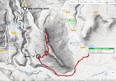
It comes from the GC-104, first going South, then North again to a certain point "A" (see map below), from where the summit can be reached, following the stone men and blue paint dots.


I got a report from Geert, PA7ZEE, about his activation in Feb 2018, telling that this track is no longer possible. It is blocked by a large new windmill park. Geert did reach the summit by scrambling over the rocks from the East (starting at the horse ranch), but did advise NOT to copy his experiment ...

After some mails with Heinz, I decided to try the approach from the road GC-551 (see : "new starting point" on the map above). Parking spot is at 27.891525, -15.483009


The summit looks very close from the new starting point, but ascent is not possible from the North. One has to go South to point A again, and follow Heinz' track from there.
In short ... it is a LONG walk ! (pun intended)

It took me over 2.5 hours to get there, and 2 hours to get back to my car.
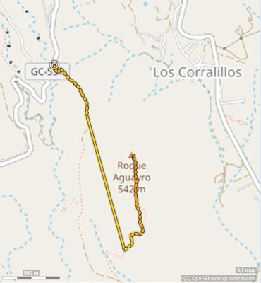
This is the track as I recorded it, but it is not complete, my phone went off without me noticing it (the part with the straight line), but it gives a general idea, and the first part of the track is easy to follow anyway. I did put it up on the Tracks page, until someone records a better one (see link above).


On the summit it was hot, so I praised myself to have taken my umbrella !


I logged 17 QSO's on this one, most on 20m, a good mix of SSB and CW.
I was happy to see 3 Belgians in my log that day : ON4FI, ON3YB and ON4VT.

For CW I tried my newest paddle : the AME Porta Paddle II with leg strap.
(https://www.americanmorse.com/portapaddle.htm)
The paddle works fine, but I wasn't really satisfied with using a leg strap. If you don't pull the strap firmly, the paddle sits loose ... but if you pull it firmly, it cuts off the blood in your leg ... and I didn't wan't a sleeping leg to start the descent of the summit ... so after that one time, I went back to my beloved Palm Pico paddle !


After this tiring walk, you would think it was time for a shower and a good rest ... but NO !

I was staying in Santa Brígida with Dolores, a lady who is also a Zumba teacher, and as it happens, Zumba is one of my other passions besides SOTA.
That evening was one of the chances to join her Zumba class. So off I went for another hour of excercise ... and in good company as you can see ;-)


Do I need to tell I slept verrrrrry well that night ?


Next summit

or

Back to overview

21/04/2018

EA8/GC-003 (Moriscos)

For this summit, I was told by Tino, EA8CLF (see my report on Pico de las Nieves) that I could drive up the forest track to a point not too far from the summit.
Start of that car track is at the parking spot along the road GC-150 here : 28.023802, -15.612962

The track has to be driven with some care, but even with my small rental car, I easily found the parking spot near the Cruz de Moriscos at this position : 28.02092, -15.61733


From there it is only a 10 minute walk to the summit, see track map below.
The track is also on the SMP Tracks Page here :
https://www.sotamaps.org/tracks/summit/EA8/GC-003


The weather was again cloudy and wet ... so I quickly setup on the highest possible point .. a pile of rocks near the gated property on the summit itself (also the vertice is not accessible to the public), hoping to do some good catches .. who knows I could work some NA activators ?


I was QRV at 13:30 UTC and kept calling for one hour and a half ... until I had to QRT because of the rain.
This got me 29 QSO's in the log , of which 10 were S2S ... but NONE were DX ... so far for the NA<>EU event :-(

Next summit

or

Back to overview

EA8/GC-001 (Pico de Las Nieves)


On this day I had to move from one AirBnb place in El Goro to another one in Santa Brígida, and I had planned to do 2 summits, so I had quite a busy schedule !

April 21st was also the day of the EU<>NA SOTA event, so I didn't want to miss that.


EA8/GC-001, Pico de las Nieves is the highest summit on Gran Canaria, and it is an easy drive-up. Parking spot is at 27.962087, -15.571974 , and is next to the Vertice. The really highest point is here 27.961416, -15.571399 , but is not accessible to the public. The spot near the vertice is in the AZ, so that was no problem.

NOTE : both Google Maps and the SOTA database show an incorrect location of "Pico de Las Nieves", that location is only at 1890 m altitude, so it is not even in the AZ.
The real peak is at 1949m, so the reported altitude of 1956 m is also wrong !
More precise information can be found here

As the name says, this summit can be covered in snow, or if you don't see any snow, it can still be very cold up there.
I was there at the end of April, and temperature was +2 °C, but with the wind chill factor ... it was freezing cold !


To my surprise, I arrived at the summit to find another ham already had set up at the parking spot.
It turned out to be Tino, EA8CLF ("Canarian Liberation Front" ;-)
He was not there for SOTA, but had setup a repeater in his car, with a vertical antenna on a pole next to the car.

The repeater was to be used for a car rally on neighbouring island Tenerife ... some 100 km away !
As it turns out, hams from the South of Tenerife cannot easily communicate with the North of the island, but they can work each other via this repeater at 2000m altitude !
Radio waves work in mysterious ways ...


After I explained to Tino what I was doing with the stuff in my backpack, he didn't lose sight of me and wanted to know all about SOTA. He showed me a nice spot to setup and keep myself  a bit out of the cold wind .. and also served as my personal photographer ... resulting in a whole bunch of pictures, more than I can show on this page. Thanks a lot Tino !

He also gave a valuable tip on going to my next summit, as you can see in my report about EA8/GC-003 Moriscos.


After tying my fishing pole to the railing near the vertice, and fixing my enfed I started calling at 09:45 UTC. Conditions were not very good, in one hour I only managed to make a mere 12 QSO's, most were on 20m CW and SSB.
But I was still happy, as 3 of those QSO's were S2S.

After being on the summit for over 2 hours, I was getting wet and cold and it was time to move to my next summit ... and put on the heating in the car ... yes,  this is also Gran Canaria !

Next summit

or Back to overview

20/04/2018

EA8/GC-026 (Montaña de Arucas)


For my first activation on Gran Canaria, I chose an easy drive-up summit.
However the drive up the summit may be easy .. the drive through the narrow and steep streets of Arucas is not. The smaller your car, the better ! 


On the summit, there is a large parking area around the big cross. Parking position is 28.124887, -15.522742

For my activation I chose a spot a bit out of sight, below the parking lot at the South side, accessible via a stone staircase. The few trees down there also gave me some shade.


Setup was my usual KX3 at 15W and 9.15m endfed.
I started calling CQ at 09:10 UTC on 20m CW.
Conditions were rather poor, but I still managed to make 12 QSO's, and 2 of those were S2S. 
Not too bad as a start. 
At 10:30 UTC I had to give up because it started raining, so I went to eat my sandwich in the car. When the rain stopped I tried calling on 2m FM, but had no luck there ...

After the activation I went to visit the very nice town of Firgas, the "Villa del Agua" or the "Water City". It is the origin of the water with the same name that you can buy everywhere on the island.
More info on Firgas here https://en.wikipedia.org/wiki/Firgas


The main attraction in Firgas is the "Paseo de Canarias", which has beautiful decorations with typical ceramic tiles.


or


18/04/2018

ON7DQ Gran Canaria SOTA tour - April/May 2018

This year I wanted to add another Association to my list, to get a step closer to the GOLD Mountain Explorer Award. I decided on EA8/GC, Gran Canaria.
As it turned out , the return plane ticket was cheaper if I came back after 3 weeks instead of 2.
So off I went on April 18 ... only returning on May 9th. Plenty of time to activate 9 summits.


I activated the following summits as EA8/ON7DQ (see red circles on the map):


Date             Summit                            QSO  Points
20/Apr/2018 EA8/GC-026 (Montaña de Arucas) 12 1
21/Apr/2018 EA8/GC-001 (Pico de Las Nieves) 12 10
21/Apr/2018 EA8/GC-003 (Moriscos)    28 10
23/Apr/2018 EA8/GC-022 (Roque Aguairo)             17 1
26/Apr/2018 EA8/GC-010 (Morro de la Hierba Huerto) 21 10
28/Apr/2018 EA8/GC-024 (Amagro)                     27 1
29/Apr/2018 EA8/GC-025 (Pico de Gáldar)            18 1
30/Apr/2018 EA8/GC-006 (Tamadaba)                  24 10
05/May/2018 EA8/GC-011 (Montaña de Tauro)          34 8

Click on any of the links above to read the full report for that summit.
Need even more info ? Send me a mail on my qrz.com address, and I'll send you everything you need to know.

I did visit the ones in a yellow circle, but did not activate them.
26/Apr/2018  EA8/GC-002  (Roque Nublo)         ( impossible to climb, at least for me! )
07/May/2018 EA8/GC-012  (Amurga)                 ( had to return because of  fatigue and bad wx )


Some statistics :

I drove 1334 km in 22 days on the island, in a small Citroën C1 rental car. 
I stayed in 4 different places, all booked via AirBnb, and met some lovely people !
I made 193 QSO's from 9 summits, which got me 52 activator points.
I made   34 S2S QSO's, resulting in 172 S2S points.

Many thanks to Geert PA7ZEE and Heinz OE5EEP for all the invaluable help in preparing this trip !

See you on the next one !

73,

Luc - EA8/ON7DQ  >>> Read about my first summit here :